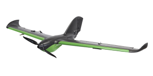
The PHX drone is a fixed-wing platform revolutionizing the drone industry and how it defines precision, reliability, and data accuracy. By utilizing a robust autopilot, the PHX is an exceptionally accurate, easy-to-use UAV system. The PHX has a cruise speed of 35 mph and up to a 59-minute endurance, allowing it to capture data from over 700 acres in a single flight. The hand-launched UAV seamlessly integrates a wide range of sensor options capable of capturing high-resolution RGB, NIR, NDVI, NDRE, 3D, thermal and LiveNDVI™ data.
Leverage the PHX Pro RTK variant to achieve sub-5cm and better accuracy on orthomosaics and 3D mapping and modeling products — without the need for surveyed ground control points or time-consuming post-processing of the GPS data. An ideal solution for survey, agriculture, and mapping customers who need to reliably — and quickly — capture precision data, the dual-band RTK payload delivers true L1/L2, multi-constellation RTK to the PHX Pro. The PHX RTK shatters the cost barrier for industrial-grade, dual-frequency RTK-enabled image collection.
The PHX drone is indispensable to growers, agronomists, crop consultants, surveyors, infrastructure inspection agents, and public safety officials.
This project is funded by the European Community Erasmus programme.